|
|
自然環境
| |
Geological
Features
|
|
| |
Fenghsan's land, in terms of the soil's drainage and nutrient
holding capacity, can be categorized into three types: high-yielding
rice fields, dry fields and barren slope land. First of all, the deposition
area at the end of Mt. Ali makes up Fenghsan City.
|
The upper layer is covered with sand and mud carried by Fenghsan
Stream; for this reason, the texture of the yellowish soil appears
sandy. In late Ming dynasty, the early immigrants, who migrated to
Taiwan with Cheng, Cheng-Kung toiled and cultivated this piece of
plain. By applying the farming skills from home and irrigating the
crops with the water from natural resources, they finally turned this
place into high-yielding rice fields. Furthermore, some other areas
which were short of water supply turned out be dry fields. As to the
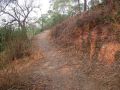
slope land, owing to its content of unwanted or harmful chemicals
like iron oxide, its texture appears tough and rough; accordingly,
it is barren and thus not good for farming. The area around Chihsan
is one of its kind. |
 |
| |
|
)
)
)
)